
5 hectare plot of land with commercial and industrial use on the Apizaco–Tlaxco highway, JM Morelos, Apizaco, Tlaxcala
Address
Plot 117 Z-1 P-2/2, José María Morelos community (near the landfill), Apizaco–Tlaxco highway
City/
Municipality
Apizaco
State
Tlaxcala
Price
Price upon request
Use
of soil
Commercial and industrial
Description :
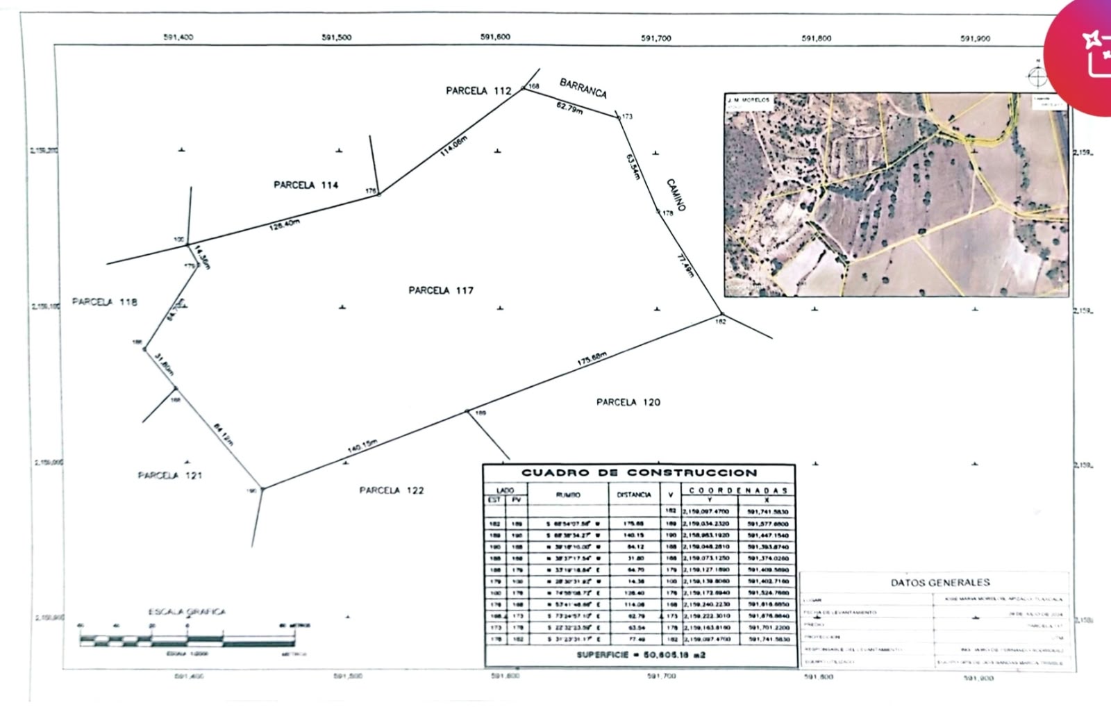
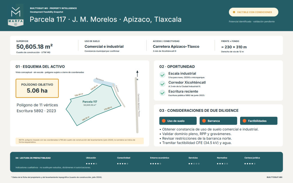
Land of 50,605.18 m² (plot 117 Z-1 P-2/2) in the community of José María Morelos, municipality of Apizaco, Tlaxcala, near the landfill on the road to Tlaxco. The property has an irregular polygonal shape with 11 vertices, with approximately 230 m frontage y 310 m deep, and features public deed 5892, volume 49, dated June 16, 2023.
It is located on the Apizaco–Poza Rica corridor, 3 minutes from the Xicohténcatl III Industrial City Located just 7 minutes from Xicohténcatl I, this commercial and industrial land is zoned for development and has access via a 12-meter right-of-way. It's a prime location for industrial buildings, logistics facilities, or a small industrial park in the northern part of the Apizaco metropolitan area. Contact Marfa BTS for pricing and terms.
Land details:
Total area
Forehead
Depth

Services
Infrastructure in the vicinity of the property:
- Electrical energy: 34.5 kV medium voltage line at about 180 m, over the road towards the Xicohténcatl III Industrial City.
- Drinking water: network on the same road; feasibility and capacity to be confirmed with the operating agency.
- Drainage: without identified network on the property; consider treatment plant or autonomous solution.
- Access: right-of-way 12 m wide and easement passage on 3 of its sides.
Transparency note: The proximity of infrastructure does not imply approved feasibility studies; these must be processed with CFE and the water operating agency.
Roads
Access and approximate times:
- Apizaco–Tlaxco highway (Apizaco–Poza Rica corridor) with access road to the property.
- Xicohténcatl III Industrial City: 3 min. Xicohténcatl Industrial City I: 7 min.
- Tlaxco: 7 min north, with connection to the free road and highway towards Chignahuapan, Zacatlán, Huauchinango, Xicotepec and Poza Rica.
- Tetla: 5 min south. Apizaco: 9 min.
- Direct connection to the Huamantla industrial corridor and the Arco Norte via Apizaco.
Economic triggers of the area
The northern part of Apizaco and Tetla de la Solidaridad form the main manufacturing hub of Tlaxcala, organized around the industrial cities of Xicohténcatl, where dozens of national and international companies operate.
- Xicohténcatl I, II and III Industrial Cities (Tetla de la Solidaridad).
- Companies in the area such as Kimberly-Clark, Owens Corning and ODW-Elektrik.
- Huamantla industrial corridor (automotive and auto parts cluster).
- Apizaco–Tlaxco–Poza Rica highway axis towards the Sierra Norte of Puebla and the Gulf.
- Demand for industrial land outside of industrial parks due to nearshoring in the center of the country.
Development potential
Due to its scale and its commercial and industrial vocation, the site allows for development built-to-suit:
- Industrial building or distribution center for suppliers of the Xicohténcatl industrial cities.
- Micro industrial park with lots or modular buildings for rent.
- Storage, maneuvering or transfer yard on the Apizaco–Tlaxco corridor.
- Commercial and service facilities for the working population of the area.
- Wifi
- Pool
- AC Service
- Parking Lot
- Gym Center
Georeferencing:
Considerations
Before committing to a project, the following must be verified:
- Land use: obtain the municipal certificate that confirms the commercial and industrial use and the applicable coefficients.
- Ejido origin: The plot comes from the ejido system; validate full ownership, registration in the RPP and absence of encumbrances.
- Ravine to the north: Review federal zone, runoff, and construction restrictions on the northern boundary.
- Nearby landfill: assess the impact on the property's intended use (suitable for industry, not for housing).
- Easements and access: Confirm the easement steps on 3 sides and the 12m right-of-way section for tractor-trailers.
- Geometry and trees: irregular polygon with scattered trees; define the usable platform.
Feasibility level
Feasible under certain conditions: good scale, recent deed, and location within the Xicohténcatl industrial corridor. Viability depends on confirming land use, energy and water availability, and ravine restrictions.
Feasibility indicators
Preliminary reading of Marfa BTS on a scale of 0 to 100 based on available information about the property and the market. It does not replace technical studies, reports, or authorizations.
We exceeded expectations
Built to suit projects
Tailored to your specific needs
562+
Developed projects
25+
Years of experience
400+
Satisfied Customers